
The first time I tackled the Jurassic Ridge Trail, I thought, “How tough could it really be?” Within minutes, I was scrambling over rocks and questioning my life choices.
But the payoff? Absolutely worth it. Towering trees, winding paths, and those jaw-dropping views of Howe Sound made every sweat-soaked step feel like a victory.
Now, after a few more treks, I’ve learned the ropes—like bringing snacks that aren’t just granola bars and knowing when to pause for that perfect Instagram shot (trust me, you’ll want to).
Jurassic Ridge is the kind of trail that challenges you, but with the right tips and a sense of humor, it’s an adventure you won’t forget.
- Best Time to Hike the Jurassic Ridge Trail
- Overview of Jurassic Ridge Trail
- How to Get to the Jurassic Ridge Trail
- Getting to the Jurassic Ridge Trailhead
- Jurassic Ridge Hike Route Summary
- Trail Highlights at the Jurassic Ridge Trail
- Safety Tips for Hiking Jurassic Ridge Trail
- FAQ
- Apps to Download for a Trip to Jurassic Ridge Trail
Best Time to Hike the Jurassic Ridge Trail
The best time to hike the Jurassic Ridge Trail is between March and October when the park is less crowded. However, the trail is a year-round delight for those eager to explore in any season.
For the best views of Howe Sound, especially around sunset, consider hiking in the late afternoon. The golden hour light makes the scenery even more spectacular!
Overview of Jurassic Ridge Trail
Distance: 3.2 kilometers
Elevation Gain: 260
Duration: 1 hour
Difficulty: Easy/Moderate
Parking: Parking for the Jurassic Ridge hike is at the Murrin Provincial Park lot, conveniently located just off the Sea to Sky Highway, but heads up—it fills up fast in the summer. If you’re hiking during peak season, plan to arrive early to snag a spot!
Trail Conditions: Be prepared for a technical trek with roots, rocks, and ropes that can slow you down. .
How to Get to the Jurassic Ridge Trail
By car: from Vancouver, head to Marine Drive ramp to Whistler. From there, turn right onto Taylor Way and watch out for signs for Squamish/Whistler. Then, merge onto BC-99 N and turn left to reach the park.
Unfortunately, there’s no public transport directly to the Jurassic Ridge Trail from Vancouver. If you don’t have a car, consider downloading car-sharing apps like Evo or Modo to get there with ease.
Getting to the Jurassic Ridge Trailhead
From the Murrin Provincial Park parking lot, walk past the park map and follow the trail to Browning Lake. Then, keep an eye out for a sign and trail on your right, which will take you to Jurassic Ridge.
Jurassic Ridge Hike Route Summary
The Jurassic Ridge Trail starts at the northern part of Browning Lake, and as you reach the northwest end, you’ll be led into a forest. This is where your hike on the Murrin Loop Trail starts.
Once you get to the junction, this is where we’d recommend that you tackle the trail counterclockwise, as it makes the ascent to the ridge a bit easier. From here, the journey will be steep and rugged, but most sections have wooden or rock steps.
Fair warning though; the trail is narrow and slippery, so make sure to be aware of other passing hikers. After that’s done, make sure to look for a junction where the trail veers to the left. From there, you’ll come across another signpost that will lead you to Jurassic Ridge.
With a rocky and slippery train, perhaps the one thing we can be thankful for is that the Jurassic Ridge Trail is well-marked; however, the path along the ridge is less obvious and requires careful navigation.
Along your journey, you’ll encounter several viewpoints overlooking the Sunshine Coast mountains and Howe Sound. Once you’re done soaking up the views, the descent is quite challenging. You’re going to need careful navigation to get around the slippery rock faces.
After that, you’ll eventually join the Murrin Park Loop trail, and the final stretch will lead you back to Browning Lake. After about 500 meters through the forest, you’ll return to the starting point.
Trail Highlights at the Jurassic Ridge Trail
Browning Lake
Media credit: alluring_odyssey
Browning Lake, a cozy and warm spot in Murrin Park, features a scenic waterfront trail and a sandy beach for exploration. It’s the first highlight of your hike and the perfect place to unwind as you descend Jurassic Ridge.
You can find secluded spots for a quick dip or enjoy splashing around on the two beachy shores on the north side, near the parking lot. Definitely pack a bathing suit! The lake’s so inviting, you’ll want to take a refreshing dip to cool off after your hike.
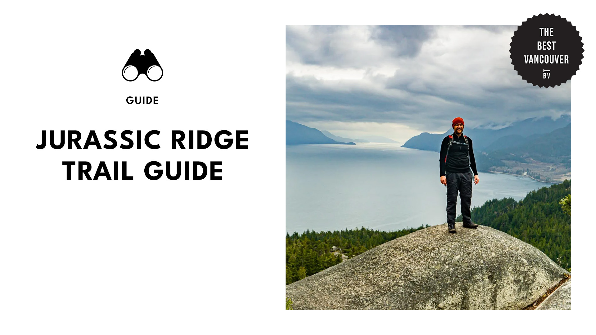
Jurassic Ridge Summit
Media credit: frenchexploreur
The Jurassic Ridge Summit is the crowning glory of the trail, offering a breathtaking finale to your hike. Perched high above, the summit provides panoramic views that are well worth the effort to reach.
From this vantage point, you’ll be treated to sweeping vistas of Howe Sound, with its sparkling waters stretching out below and framed by rugged mountains. On clear days, you can even catch glimpses of the Sunshine Coast in the distance.
Quercus Viewpoint
Media credit: greyeyedguy
The Quercus Viewpoint offers a stunning panorama where you can gaze out over Howe Sound, catch a glimpse of Browning Lake below, and admire the surrounding mountains.
While there are several great vantage points along the trail, they all generally offer similar views in the same direction.
Safety Tips for Hiking Jurassic Ridge Trail
• If you’re tackling the Jurassic Ridge loop, make sure you’re equipped with sturdy footwear and keep an eye on the signs—it’s easy to get turned around! The descent is steep and rocky, so good grip is a must.
• You’ll be scaling smooth, steep rock surfaces with the help of ropes and ladders, so ensure you have the proper gear and some climbing experience before you go.
• If you want to tackle the mountain scramble first, start clockwise; if you prefer to save the hardest part for last, go counter-clockwise (the standard route).
• With so many trails in the park, it’s easy to get lost, so downloading a map is a smart move, especially if you’re going the unconventional way.
• Wrap up your hike before 4 p.m. as it gets dark quickly in the forest. A map, GPS, or navigation app is a good idea to keep you on track.
FAQ
Apps to Download for a Trip to Jurassic Ridge Trail
Maps.me: detailed, offline maps with turn-by-turn navigation for driving, hiking, or biking to a selected location.
AllTrails: a running and hiking app with over 400,000 trails, trail information, maps, detailed reviews, and photos.
PayByPhone: cashless parking app that lets you register and pay for parking in Vancouver.
GasBuddy: locates gas stations near you and displays prices, sends price hike alerts, and notifies you of deals.